Elucidating the Role of Cloud-Circulation Coupling
in Climate
Mission status: Completed

Figure 3.22: Schematic plan of envisioned platform deployment during EUREC4A east of Barbados during January and February 2020

Mission status: Completed
Bjorn Stevens (MPI-M)
Lutz Hirsch (MPI-M)
From – To
| Mission phase | Dates |
|---|---|
| Mission phase | Date |
| Mission phase | Date |
| Mission phase | Date |
A better quantification and physical understanding of how clouds respond to warming, and hence Earth’s Equilibrium Climate Sensitivity is recognized as one of the Grand Challenges of Climate Science. Research over the past decades has advanced to the point that testable hypotheses have been articulated, and these motivate “Elucidating the Role of Cloud-Circulation Coupling in Climate” (EUREC4A). The EUREC4A field campaign in January and February 2020 in the vicinity of Barbados will elucidate how the macrophysical properties of trade-cumuli depend on the dynamic and thermodynamic properties of the environment in which the clouds form. As two primary objectives, we will
EUREC4A has attracted a lot of international attention. In addition to HALO and ATR-42 two additional research aircraft and four research vessel will join the campaign as additional platforms. The ships will host numerous autonomous observing systems of the atmospheric boundary layer or the ocean. The measurement setup is displayed in Fig. 3.22. The large international attention is also recognized by The World Climate Research program (WCRP), which has endorsed EUREC4A as capstone experiments of the Grand Science Challenges on Cloud Circulation and Climate Sensitivity. In parallel EUREC4A has become the nucleus for other related scientific activities that intend to join the experiment and will enrich the data set: EUREC4A-OA/ATOMIC (European Ocean-Atmosphere component of EUREC4A / Atlantic Tradewind Ocean- Atmosphere Mesoscale Interaction Campaign by the US) will coordinate the four research vessels. They will observe ocean state and exchange fluxes and will serve as platforms for ground based remote sensing and in-situ profiling by radiosondes of the cloudy atmosphere. EUREC4A-ISO will explore the water isotope signature and help to disentangl the various processes affecting the water budget of cumulus clouds. EUREC4A-Wind will bring together investigators from different institutes to promote a better understanding of the coupling of winds, convection and clouds and their importance for weather and climate prediction in the trades. In particular, this initiative will explore and validate the potential of the ESA ADM-Aeolus mission. EUREC4A-Model will accompany the campaign with high-resolution numerical simulation with a grid spacing of 1 km or less using the ICON model and link the campaign with most recent cutting-edge initiative of cloud resolving global models (cf. Dyamond project, www.esiwace.eu/services/dyamond).
Figure 3.22: Schematic plan of envisioned platform deployment during EUREC4A east of Barbados during January and February 2020
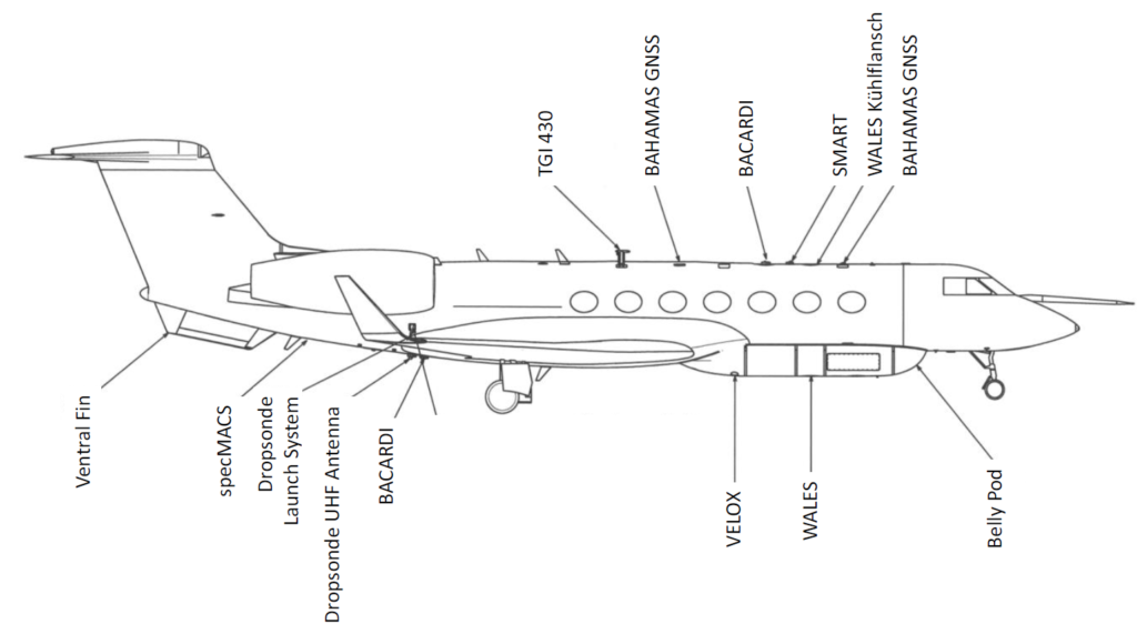
| Scientific instrument acronym | Description | Principal investigator |
|---|---|---|
| HAMP Cloud Radar | The radar is a nadir staring instrument that measures in the water-vapor window at a frequency of 35.5 GHz (Ka-band). This system, similar to cloud radars operated on the Barbados Cloud Observatory, is operated with a 200 ns pulse length and a pulse repetition frequency of 5kHz. Two receivers provide co- and cross-polarization reflectivity measurements. | Lutz Hirsch (MPI-M) |
| HAMP Radiometer | Three downward looking radiometer modules passively measure the microwave emissions of Earth’s atmosphere in twenty-six channels probing two water vapor and two oxygen absorption features, as well as window channels. Beam widths of 2.7º to 5.0º and a sampling rate of about 1 s. | Friedhelm Jansen (MPI-M) |
| WALES Lidar | WALES operates at four wave-lengths near 935 nm to measure water-vapor mixing ratio profiles covering the whole atmospherebelow the aircraft. At typical flight speeds it has a resolution of 200 m in the vertical and 6 km in the horizontal. The system also contains additional aerosol channels at 532 nm and 1064 nm with depolarization. WALES uses a high-spectral resolution technique, which distinguishes molecular from particle backscatter, to make direct extinction measurements with a resolution of 15 m in the vertical and 200 m in the horizontal.
| Martin Wirth (DLR-IPA) |
| SMART | The Spectral Modular Airborne Radiation measurement sysTem (SMART) measures spectral irradiances from zenith and nadir oriented sensors. An additional nadir looking sensor measures radiances. Measurements span the visible and near infrared (300 nm to 2200 nm) with a 2 nm to 3 nm spectral resolution for wavelengths shorter than 1000 nm and a 10 nm to 15 nm spectral resolution for longer wavelengths. | André Ehrlich (Leipzig Univ.) |
| specMACS | The spectrometer of the Munich Aerosol Cloud Scanner (specMACS) consists of two camera systems, both looking nadir, one in the visible/near-infrared (400 nm to 1000 nm), and another in the short-wave infrared (1000 nm to 2500 nm). The systems produce a spectrally resolved line image with 1312 pixels covering a 32.7º field of view in the visible/near infrared, and with 320 pixels covering a 35.5º field of view in the short-wave infrared. | Tobias Zinner, Veronika Pörtge (LMU München) |
| VELOX | A broadband camera system with a filter to take broadband (7.7 μm to 12 μm) and narrow band images near 8.6μm, 10.8 μm; 11.6 μm; and 12 μm. The camera has 640x512 spatial pixesl for a 21.7° x 17.5° field of view. This gives roughly 6m by 6m spatial resolution for a target at 10 km distance. The camera operates betwen -60ºC and 100ºC with a sensitivity better than 0.05 K. | Michael Schäfer (Leipzig Univ.) |
| Dropsondes | AVAPS dropsonde system using Vaisala RD-94 sondes to measure temperature with an accuracy of 0.2 ºC, humidity with an accuracy of 2 %RH, pressure with an accuracy of 0.4 hPa. Winds are derived from GPS position measurements with an estimated accuracy of 0.1 m/s. The receiver can track four sondes simultaneously. For the measured descent time of about 750 s from a drop altitude of 9.5 km, the capability of the receiver allows a sonde to be launched roughly every three and a half minutes. Anna | Lübcke, (Leipzig Univ.) |
| BAHAMAS | Aircraft state variables, position, three-dimensional turbulent winds (from five hole probe on boom), humidity (diode laser), temperature and pressure. | Andreas Giez (DLR-IPA) |
| BACCARDI | Broadband radiometers for downwelling and upwelling irradiances in both the SW (< 4 μm) and LW parts of the spectrum. | Andreas Giez (DLR-IPA) André Ehrlich (Leipzig Univ.) |
| Aircraft registration | Date | Take off - Landing / UT | Total flight time / h | From - To | Mission # |
|---|---|---|---|---|---|
| D-ADLR | Date | hh:mm:ss - hh:mm:ss | h | CODE - CODE | 1 |
| D-ADLR | Date | hh:mm:ss - hh:mm:ss | h | CODE - CODE | 2 |
| D-ADLR | Date | hh:mm:ss - hh:mm:ss | h | CODE - CODE | 3 |
| D-ADLR | Date | hh:mm:ss - hh:mm:ss | h | CODE - CODE | 4 |
| D-ADLR | Date | hh:mm:ss - hh:mm:ss | h | CODE - CODE | 5 |
| D-ADLR | Date | hh:mm:ss - hh:mm:ss | h | CODE - CODE | 6 |
| D-ADLR | Date | hh:mm:ss - hh:mm:ss | h | CODE - CODE | 7 |
| D-ADLR | Date | hh:mm:ss - hh:mm:ss | h | CODE - CODE | 8 |
| D-ADLR | Date | hh:mm:ss - hh:mm:ss | h | CODE - CODE | 9 |
| D-ADLR | Date | hh:mm:ss - hh:mm:ss | h | CODE - CODE | 10 |
| D-ADLR | Date | hh:mm:ss - hh:mm:ss | h | CODE - CODE | 11 |